Unique Levels Lingo
The landscape has its own fascinating local ‘Levels Lingo’ or vocabulary that provides an insight into the origins of the landscape over 1800 years ago and how it continues to be managed today
In preparation for the Living Levels project, Historian and Archaeologist Rick Turner created 'Levels Lingo', a glossary of words and phrases used on the Gwent Levels historically and today. Levels Lingo now covers the Somerset Levels and Gloucestershire Levels too, and later in 2021, a much expanded edition will be available online. Not every term is unique to the area, but each one forms an intrinsic part of the cultural heritage of the Severn Estuary Levels.
Some examples of this unique watery lexicon are included below.
Arch
An arched bridge over a watercourse sometimes incorporating top-hinged tide flap.
Back-fen
The lower-lying landward edge of the Levels (e.g. at Magor Marsh). The Levels slope downwards from the seaward edge inland and the back-fen is on average 2m lower than the coastal edge. The back-fen was traditionally the wettest part of the Levels and was the last to be properly drained.
Brinker
A person who owns land on one side of a reen, wall or pill and is responsible for its maintenance – derived from 'Brinker', a person living on the brink or border.
See: Anne Williams, Brinker
Bungum
A local word for the silty estuarine clay used to bung up holes in banks etc.
Cast or throw a ditch
Originally, a ditch was cast or thrown up with a spade or shovel to remove the silt and clean it back to the original profile. Today, this work is undertaken mechanically.
Causeway
A raised passage across low-lying lands (e.g. The Causeway, Undy).
Court of Sewers
Henry VIII established courts of sewers in 1531. These held jurisdiction over the maintenance and repair of land drainage and flood defence mechanisms in specified areas of coastal lowland. Monmouthshire Court of Sewers eventually became the Caldicot and Wentlooge Levels Internal Drainage Board. Today, Natural Resources Wales fulfil a similar role.
See: Court of Sewers
Gout
The word 'gout' comes from the Old English word 'gota', and Middle English 'gote', meaning watercourse, channel, drain or stream. Gout can refer to a channel that takes water through a structure to the sea, a sluice or floodgate, or a covered drain or culvert. It is sometimes pronounced 'gut' on the Gwent Levels.
Grips
Small open furrows or ditches, especially for carrying off water. Often seen as spade-dug gullies in the surface of fields to aid drainage.
See: Reens, ditches and grips
Lave net
A hand-held 'Y' shaped net used to catch salmon. The frame comprises the head board (yoke), rimes (arms) and rock staff (handle). It folds, making it easier for the fisherman to carry as he wades into the estuary to wait for a salmon. The net within the frame is hand knitted.
See: Lave net fishing
Linch or lynch
A small inland cliff. Lynches is the local name for the mud cliff on Rumney Great Wharf.
Noggle. noghole and noggor
The Monks Ditch is an artificial watercourse thought to have been constructed in medieval times by the monks of Goldcliff Priory. It runs across several reens at a higher level. Previously at an intersection, wooden planks in the base of the Monks Ditch contained a hole (noggle or noghole) and a wooden peg (the noggor). These enabled the transfer of water to adjacent reens. Today, the same is accomplished by a valve encased in a protective structure at the side of the Monks Ditch that opens a pipe.
Outfall
The place where draining water flows out of a reen or other watercourse into a larger body of water (e.g. the Severn), sometimes known as a gout. Major tidal outfall structures built into sea defences comprise a penstock on the landward side and a tide-flap, tide-gate or similar on the seaward side
Pill
A Severn Estuary term for a tidal creek, the section of a watercourse seaward of an outfall or gout. Pill may be derived from the Welsh 'pwll', meaning pool.
Putcheon
A woven fish trap made from willow fitted with constrictions (throats or chales). These prevented an eel, elvers (young eels), lampreys and twaite from turning around and swimming back out. Putcheons were baited with a piece of rabbit or lamprey, weighted with stone, and laid in a river, tethered to the bank.
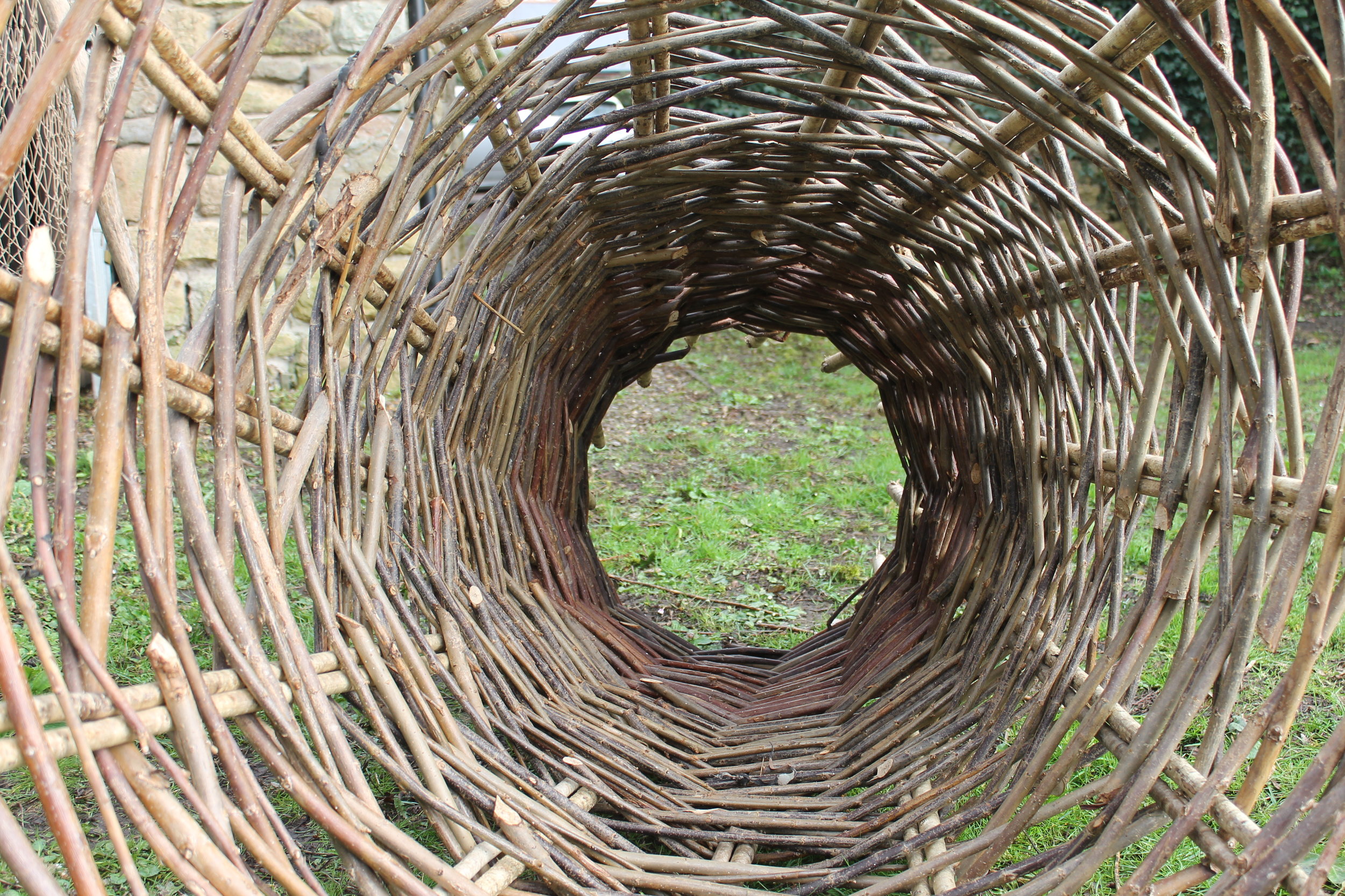
Putchers
Conical willow and hazel baskets set in ranks facing the ebb tide to catch salmon and other fish. Their funnel shape prevents the fish from escaping. Many hundreds of putchers can be set into the framework of the ranks.
See: Putcher Fishing
Putt or kype
A basket for trapping fish, divided into three parts: the large conical forewheel, the central butt, and the diddle which closes the end and traps the fish. Bigger fish were caught in the butt, and shrimps in the diddle.
Reaping and scouring
These maintenance tasks ensure that reens are kept free of vegetation and silt.
Reens
Large open ditches or drains which are the primary feature of a complex drainage system that conveys surface water to the sea. Reens have formed an intrinsic part of the Levels landscape since Roman times. They are abundant in wildlife and provide drinking water for livestock. Traditional methods of keeping them free of vegetation and silt involved hand-held tools such as the drashing hook (long-handled curved blade) and crab (long-handled fork). Today most of this work is accomplished by machine.
See: Reens, ditches and grips
Reen vaulting
Once a popular sport practised on the Gwent Levels, this involved leaping across a reen with the aid of a wooden pout or powt (a pole used by fishermen to spear salmon or force them from the banks of rivers).
Ridge and vurrow
Flatter-topped corrugations in the surface of a field, created through ploughing, to aid the drainage of pasture or meadow. Different to ridge and furrow (the rounded corrugations in the surface of a field resulting from the use of a non-reversible plough for arable farming, typical of the open field system).
Rotten lands
A name sometimes given to damp, boggy ground, often saturated with rain, where sheep are prone to suffer from the rot. Llanwern Steelworks was built on Bishton's Rotten Lands.
Saltmarsh
A marsh overflowed or flooded by the sea. Often this can be used for summer grazing when the tides are generally lower.
See: Beyond the sea wall
Sea walls
Sea walls are found as various constructions depending on the vulnerability of the location. Repairs to grass embankments include earthing (filling in areas washed out by erosion), turfing (replacing the top covering of turfs) and heading (reinstating the crest height). Some sea walls are faced in stone or built of concrete for added protection.
Sewer
An artificial watercourse for draining marshy land and carrying off surface water into a river or the sea. Sewers are the collective name for any type of watercourse on the Levels.
Stank
A stank can be a pond or pool, a ditch of slowly moving water, a dam to hold back water or a weir. Many stanks are inhabited by moorhens, known locally as the 'stankhen'.
Tide flap or tide gate
A flapped opening through which surface water flows towards the sea on the ebb-tide, but closes against the flood-tide to prevent tidal ingress inland.
Watering
A semi-circular sloping hollow cut out of a ditch or reen bank to allow animals to drink, sometimes reinforced by wooden piles or given a concrete base.
Wet fence
A reen or ditch along a field boundary whose water ensures that livestock are kept within the field.
Wharf
A flat meadow, especially low-lying grazing lands along the Severn Estuary. Sometimes referred to as salt wharf or fresh wharf depending on its position relative to the sea wall.
Wrack
Wreck and debris cast ashore by the tide.
A taste of the Levels
Gwent Levels based micro-brewery Anglo-Oregon have produced a trio of ales, which are inspired by the historic ‘Levels Lingo’. You can order your bottles of ‘Stank hen’, ‘Brinker’ and ‘Putcher’ from Anglo-Oregon.